
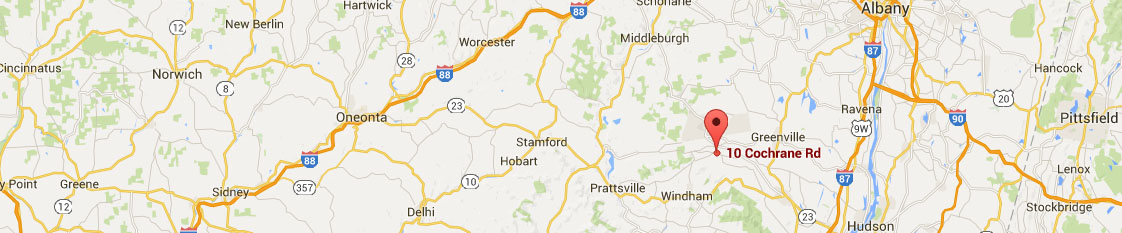
From South (New York City)
From NYS Thruway I-87, take exit 21/Catskill. From tollbooth take left to RT-23 West. From tollbooth take left to RT-23 West. Take RT-23 West and continue past McDonald’s for approximately one more mile. Turn right on RT-145 North. Proceed on RT. 145 North for 7.5 miles following Zoom Flume signs. Turn left at Stone Bridge Rd and continue for 3.5 miles. Make sure to continue straight, without making turns, and look for all-white buildings and two silos at HULL-O FARMS.
From North (Montreal)
Take NYS Thruway (I-87) to exit 21B (Coxsackie exit).
Take left off exit ramp onto RT 9W. Proceed to 2nd traffic light and turn right onto RT 81 towards Greenville. Stay on RT 81 for 18.2 miles and turn left onto CR 27 which is just past a cinder block town building which is on the left. Go 1 mi and turn RIGHT at “T” onto RT 145N. Go 1/2 mi and make first turn LEFT onto Brown Rd Go 1.5 mi and turn RIGHT onto Stone Bridge Rd. Go 1 mile and Hull-O Farms will be on the RIGHT.
From East (Boston)
From NYS Thruway I-90West, follow signs to NYS Thruway I-87 South/New York City. Follow NYS Thruway I-87 South to exit 21/Catskill. From tollbooth take left to RT-23 West. Take RT-23 West and continue past McDonald’s for approximately one more mile. Turn right on RT-145 North. Proceed on RT. 145 North for 7.5 miles following Zoom Flume signs. Turn left at Stone Bridge Rd and continue for 3.5 miles. Make sure to continue straight, without making turns, and look for all-white buildings and two silos at HULL-O FARMS.
From West (Syracuse)
Take I-90 (Thruway) to exit 29 (Canajoharie). At end of ramp, take Left and proceed with getting on RT 162 S. Stay on 162 which becomes 30A to light in Central Bridge. Take Left at light onto RT 7. Take Right at next light onto RT 30. Stay on this road till you get to Schoharie. Go thru Schoharie till you get to Middleburgh. At the light in Middleburg, take a Left onto RT 145. Stay on RT 145 for about 14 miles till you come to a stop light in town of Cooksburg. Proceed 2.2 miles and turn Right at sign directing you into the town of Durham. Proceed approx. ¼ mile and make a left hand turn ( there is a town historical sign at this corner). Stay on that road for approx. ¾ mile. We are on the right hand side of the “T” all white buildings and farm sign at corner.